
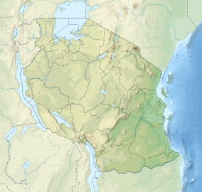
The Ngorongoro Conservation Area (NCA) is a conservation area and a UNESCO World Heritage Site situated 180 km (110 mi) west of Arusha in the Crater Highlands area of Tanzania. The conservation area is administered by the Ngorongoro Conservation Area Authority, an arm of the Tanzanian government, and its boundaries follow the boundary of the Ngorongoro Division of Ngorongoro District. The Ngorongoro Crater, a large volcanic caldera, lies within the area.
History and Geography
Based on fossil evidence found at the Olduvai Gorge, it is known that various hominid species have occupied the area for 3 million years. Hunter-gatherers were replaced by pastoralists a few thousand years ago. The Mbulu[1] came to the area about 2,000 years ago, and were joined by the Datooga around the year 1700. Both groups were driven from the area by the Maasai in the 1800s.[2] Massive fig trees in the northwest of the Lerai Forest are sacred to the Maasai andDatooga people. Some of them may have been planted on the grave of a Datago leader who died in battle with the Maasai around 1840.[3]
No Europeans are known to have set foot in the crater until 1892, when it was visited by Dr. Oscar Baumann. Two German brothers farmed in the crater until the outbreak of World War I, after leasing the land from the administration ofGerman East Africa. Dr. Baumann shot three rhinos while camped in the crater, and the German brothers regularly organized shooting parties to entertain their German friends. They also attempted to drive the wildebeest herds out of the crater.[4][5]
The Ngorongoro area originally was part of the Serengeti National Park when it was created by the British in 1951. Maasai continued to live in the newly created park until 1959, when repeated conflicts with park authorities over land use led the British to evict them to the newly declared Ngorongoro Conservation Area.[6]
The Ngorongoro Conservation Area Authority is the governing body regulating use and access to the NCA. The area became a UNESCO World Heritage Site in 1979.
Land in the conservation area is multi-use: it is unique, as it is the only conservation area in Tanzania providing protection status for wildlife whilst allowing human habitation. Land use is controlled to prevent negative effects on the wildlife population. For example, cultivation is prohibited at all but subsistence levels.
 The area is part of the Serengeti ecosystem and, to the north-west, it adjoins the Serengeti National Park and is contiguous with the southern Serengeti plains, these plains also extend to the north into unprotected Loliondo division and are kept open to wildlife through transhumance pastoralism practiced by Maasai. The south and west of the area are volcanic highlands, including the famous Ngorongoro Crater and the lesser known Empakai. The southern and eastern boundaries are approximately defined by the rim of the Great Rift Valley wall, which also prevents animal migration in these directions.
The annual ungulate migration passes through the NCA,with wildebeest and zebra moving south into the area in December and moving north in June. This movement changes seasonally with the rains, but the migration will traverse almost the entire plains in search of food. The NCA has a healthy resident population of most species of wildlife: in particular, the Ndutu Lake area to the west has strong cheetah and lion populations.
Wildlife
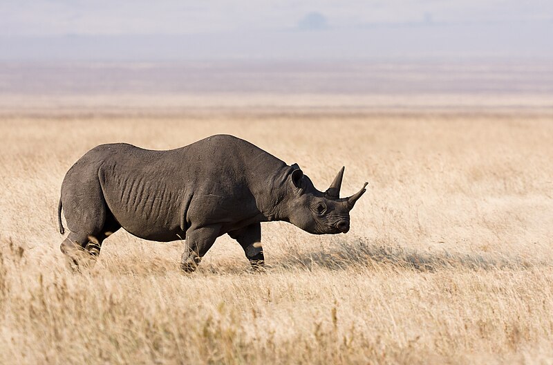
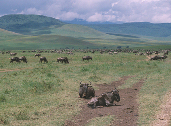
A population of approximately 25,000 large animals, largely ungulates along with reputedly the highest density of mammalian predators in Africa, lives in the crater. Large animals in the crater include the black rhinoceros, the local population of which declined from about 108 in 1964-66 to between 11-14 in 1995, and the hippopotamus, which is very uncommon in the area. There also are many other ungulates: the wildebeest (7,000 estimated in 1994), the zebra (4,000), the eland, and Grant's and Thompson'sgazelles (3,000).
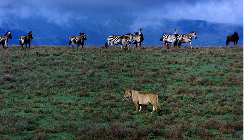
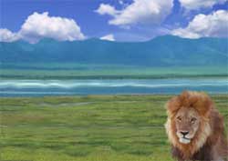
The crater has the densest known population of lions, numbering 62 in 2001. On the crater rim are leopards, elephants – numbering 42 in 1987 but only 29 in 1992 – mountain reedbuck, and buffalo (4,000 in 1994). In the middle of the crater there is a large lake inhabited by hundreds of flamingoes and from a distance, they appear as a pink border of the lake.
However, since the 1980s the crater's wildebeest population has fallen by a quarter to about 19,000 and the numbers of eland and Thomson's gazelle also have declined while the buffalo population has increased greatly, probably due to the long prevention of fire which favors high-fibrous grasses over shorter, less fibrous types.
In summer, enormous numbers of Serengeti migrants pass through the plains of the reserve, including 1.7 million wildebeest, 260,000 zebra, and 470,000 gazelles.Waterbuck occur mainly near Lerai Forest; servals occur widely in the crater and on the plains to the west. Common in the reserve are lions, hartebeest, spotted hyenas andjackals. Cheetahs, although common in the reserve, are scarce in the crater itself. The African Wild Dog has recently[when?] disappeared from the crater and may have declined elsewhere in the Conservation Area as well, as well as throughout Tanzania according to C. Michael Hogan.


Lake Magadi is the dominant feature of the Ngorongoro craterfloor.
Ngorongoro Crater
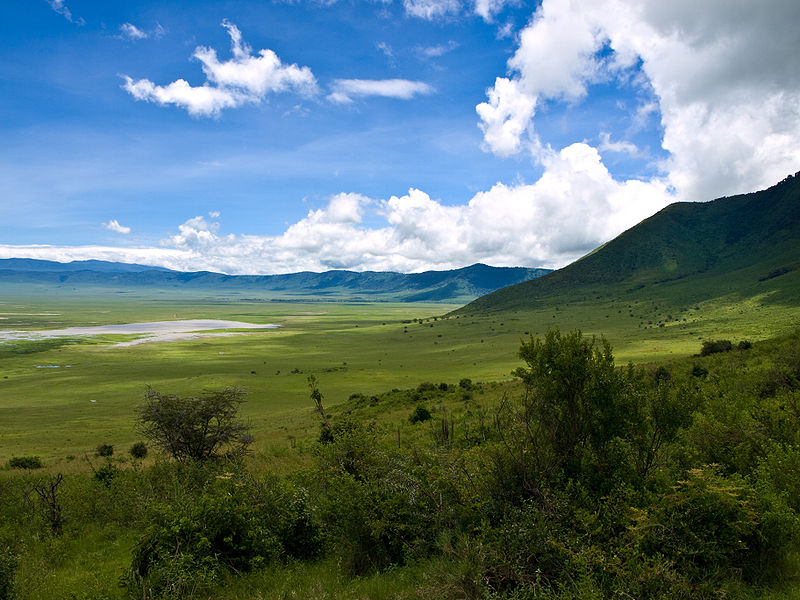
The main feature of the NCA is the Ngorongoro Crater, a large, unbroken, unflooded volcanic caldera. The crater, which formed when a giant volcano exploded and collapsed on itself some two to three million years ago, is 610 m (2,000 ft) deep and its floor covers 260 km2 (100 sq mi).[5] Estimates of the height of the original volcano range from fifteen to nineteen thousand feet (4500 to 5800 metres) high.[8][9]
Although thought of as "a natural enclosure" for a very wide variety of wildlife, up to 20% or more of the wildebeest (Connochaetes taurinus) and half the zebra (Equus burchelli) populations vacate the Crater in the wet season. However, a side effect of this enclosure is that the population of Ngorongoro lions is significantly inbred, with many genetic problems passed from generation to generation. This is due to the very small amount of new bloodlines that enter the local gene pool, as very few migrating male lions enter the crater from the outside. Those who do enter the crater are often prevented from contributing to the gene pool by the crater's male lions, who, because of their large size (the result of an abundant and constant food source), easily expel any outside competitors. Animal populations in the crater include most of the species found in East Africa, but there are no impalas (Aepyceros melampus), topis (Damaliscus lunatus), oribis (Ourebia oribi), giraffes (Giraffa camelopardalis), or crocodiles (Crocodylus niloticus).[10]
The crater highlands on the side facing the easterly trade winds receives 800–1200 mm of rain a year and is covered largely in montane forest, while the less-steep west wall receives only 400–600 mm; this side is grassland and bushland dotted with Euphorbia bussei trees. The crater floor is mostly open grassland with two small wooded areas dominated by Acacia xanthophloea.[10]
The Munge Stream drains Olmoti Crater to the north, and is the main water source draining into the seasonal salt lake in the center of the crater. This lake is known by two names: Makat as the Maasai called it, meaning salt; and Magadi.[11] The Lerai Stream drains the humid forests to the south of the Crater, and it feeds the Lerai Forest on the crater floor - when there is enough rain, the Lerai drains into Lake Magadi as well. Extraction of water by lodges and NCA headquarters reduces the amount of water entering Lerai by around 25%.[12]
The other major water source in the crater is the Ngoitokitok Spring, near the eastern crater wall. There is a picnic site here open to tourists and a huge swamp fed by the spring, and the area is inhabited by hippopotamus, elephants, lions, and many others. Many other small springs can be found around the crater's floor, and these are important water supplies for the animals and local Masaai, especially during times of drought.
Aside from herds of zebra, gazelle, and wildebeest, the crater is home to the "big five" of rhinoceros, lion, leopard, elephant, and buffalo. The crater plays host to almost every individual species of wildlife in East Africa, with an estimated 25 000 animals within the crater.
Following the recommendations of the ad hoc committee of scientists convened after the 2000 drought, an ecological burning program was implemented in the crater, which entails annual or biannual controlled burns of up to 20% of the grasslands.[10] Maasai are now permitted to graze their cattle within the crater, but must enter and exit daily.


Return to the rim of the crater for dinner and overnight.

The Ngorongoro Crater is a natural amphitheatre created about 2 million


The Ngorongoro conservation area was initially a part of the greater known

Aerial view of the Ngorongoro Crater from the Serengeti side
Ngorongoro Crater. (Tanzania). Often called the eighth wonder of the world,
Ngorongoro Crater tips you can trust

Ngorongoro Crater Lodge

NGORONGORO WILDLIFE LODGE

ngorongoro-crater-lodge - Dine with views over the crater

The main feature of the NCA is theNgorongoro Crater, a large, unbroken,

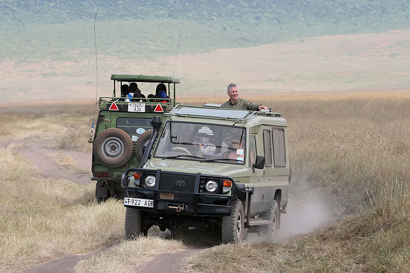
Vehicle cluster on a lion sighting in the Ngorongoro Crater
NGORONGORO WILDLIFE LODGE
ngorongoro-crater-lodge - Dine with views over the crater
The main feature of the NCA is theNgorongoro Crater, a large, unbroken,
Vehicle cluster on a lion sighting in the Ngorongoro Crater
Lion death periods and Stomoxys flies
In 1961 there was a drought, and in 1962 rain continued throughout the dry season. This caused a massive build-up of the Stomoxys calcitrans biting fly by May 1962. Their demands for blood meals affected the lions so badly (draining blood, and causing skin sores which became infected) that lion numbers crashed, and took several years to build back up when the weather was back to normal. It was estimated that Ngorongoro's population of at least 70 lions had been reduced to about 10.
Drought in 2000 and continuous dry-season rain in 2001 did the same again: in March 2001 Stomoxys numbers had built up again into a devastating plague.[13]
Additionally, Lions declined from 80 to approximately 30 in 2003 and spotted hyenas decreased by 36%.[14]
V.A. Runyero also noted the downward trend of other species and states, "Analysis of the semiannual game counts begun in 1964 indicates that the five most abundant ungulates in the Crater declined 29% between the periods 1964–1980 and 1986–2005. The wildebeest, the keystone species, declined from over 14,000 to <9000 head; buffalo increased from <100 before 1970 to over 2000 individuals to become the dominant herbivore. Gazelle populations also declined.


OLDUVAI GORGE
The conservation area also protects Olduvai Gorge, situated in the plains area. It is considered to be the seat of humanity after the discovery of the earliest known specimens of the human genus, Homo habilis as well as early hominidae, such as Paranthropus boisei.
The Olduvai Gorge or Oldupai Gorge is a steep-sided ravine in the Great Rift Valley, which stretches along eastern Africa. Olduvai is in the eastern Serengeti Plains in northern Tanzania and is about 30 miles long. It lies in the rain shadow of the Ngorongoro highlands and is the driest part of the region.[16] The gorge is named after 'Oldupaai', the Maasai word for the wild sisal plant,Sansevieria ehrenbergii.
It is one of the most important prehistoric sites in the world and research there has been instrumental in furthering understanding of early human evolution. Excavation work there was pioneered by Mary and Louis Leakey in the 1950s and is continued today by their family. Some believe that millions of years ago, the site was that of a large lake, the shores of which were covered with successive deposits of volcanic ash. Around 500,000 years ago seismic activity diverted a nearby stream which began to cut down into the sediments, revealing seven main layers in the walls of the gorge.
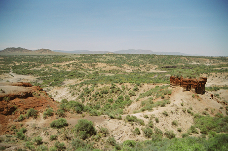
This image depicts Olduvai Gorge in nothern Tanzania.
EAST AFRICAN RIFT
The East African Rift is an active continental rift zone in eastern Africa that appears to be a developing divergent tectonic plate boundary. In the past it was considered to be part of a larger Great Rift Valley that extended north to Turkey. The rift is a narrow zone in which the African Plate is in the process of splitting into two new tectonic platescalled the Somali Plate and the Nubian Plate, which are subplates or protoplates.
Extent
The East African Rift runs from the Afar Triple Junction in the Afar Depression southward through eastern Africa. It is believed to run offshore of the coast of Mozambique along the Kerimba and Lacerda rifts or grabens,[1] terminating in the Andrew Bain Fracture Zone complex, where it is believed to have its junction with the Southwest Indian Ridge.
The East African Rift consists of two main branches called the Gregory Rift and the Western Rift Valley. These result from the actions of numerous normal (dip-slip) faults which are typical of all tectonic rift zones. The Eastern Rift Valley includes the Main Ethiopian Rift, running eastward from the Afar Triple Junction, which continues south as theKenyan Rift Valley. The Western Rift Valley includes the Albertine Rift, and further south the valley of Lake Malawi.
Volcanic activity
The East African Rift Zone includes a number of active as well as dormant volcanoes. These include Mount Kilimanjaro, Mount Kenya, Mount Longonot, Menengai Crater,Mount Karisimbi, Mount Nyiragongo, Mount Meru and Mount Elgon as well as the Crater Highlands in Tanzania. The Ol Doinyo Lengai volcano remains active, and is currently the only natrocarbonatite volcano in the world. Erta Ale is a continuously active basaltic shield volcano in the Afar Region of northeastern Ethiopia.
Discoveries in human evolution
The Rift Valley in East Africa has been a rich source of fossils[3] that allow study of human evolution.
Because the rapidly eroding highlands have filled the valley with sediments, a favorable environment for the preservation of remains has been created. The bones of severalhominid ancestors of modern humans have been found there, including those of "Lucy" a partial, yet eye-opening australopithecine skeleton, which was discovered by anthropologist Donald Johanson dating back over 3 million years. Richard and Mary Leakey have also done significant work in this region.
More recently, two other hominid ancestors have been discovered there: a 10 million year-old ape called Chororapithecus abyssinicus, found in the Afar rift, in eastern Ethiopia, and the Nakalipithecus nakayamai, which is also 10 million years old

1 comment:
chanel bags 712401 louis vuitton outlet 581660 chanel outlet store 92158 loius vuitton speed 30 739514 http://guccioutletonlinestore.snack.ws/
Post a Comment